 Services
from AtLink Communications
Services
from AtLink Communications 
AtSim is a simulation-based and design service from AtLink Communications, that provides a novel 3D visualization & simulation service platform designed to study and present construction and traffic management projects. AtSim takes a simulation-based approach, creating realistic digital models in a flexible environment to support the ever-changing nature of these projects. Our simulation technology provides an accurate, high-value, data driven output of information for review and visualization with real-time traffic.
Additional Information
AtSim offers you a simulation-based and design service that Integrates
- 3D simulation environment (AtSim Core)
- Intelligent Traffic Simulation Engine (AtSim Traffic)
- Floodwater mapping (AtSim Hydro)
AtLink is inspired by the evolution of advanced technologies and their application to modern traffic management systems. Taking advantage of the deep knowledge in 3D technology, and simulation, AtLink created AtSim. AtSim is based on the belief that in the future traffic simulations will require the ability to integrate traditional static estimation approaches with dynamic historical or live traffic data with environmental data (Terrain, elevation, lighting, etc.).
3D simulation environment (AtSim Core)
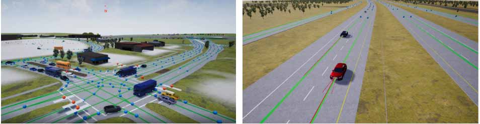
AtSim models and captures the entire network of roads, bridges, buildings, vehicles, traffic lights, road signs, lighting, pedestrians, etc. into a realistic representation.
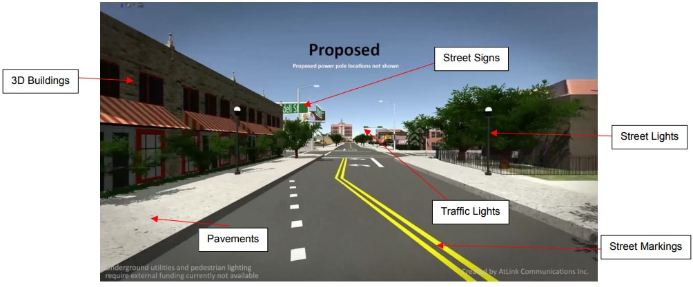
Real-time interactivity
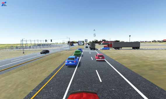
AtSim assembles the complete network of 3D models into a realistic gaming engine. This provides the AtSim users the flexibility to navigate and travel the virtual world at ease. It gives the users the wings to fly around freely while observing the traffic flows or take a “1st person” view (as if sitting in a vehicle).
Users can also select a “1st person” view (as if sitting in a vehicle).
Intelligent Traffic Simulation Engine (AtSim
Traffic)
AtSim’s ITSE takes into account environmental factors to provide a more realistic simulation. AtSim integrates with external data sources to use historical or live traffic data in its simulation. This enables realistic simulations that can simulate traffic flow of a given date and time interval to be utilized in a user’s traffic study.
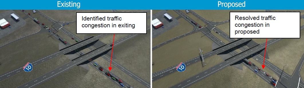
Using the Microscopic model with ITSE AtSim can identify problem areas in the traffic network for existing or proposed conditions. AtSim offers mesoscopic, microscopic, and nanoscopic simulation, all in a single unified real-time environment.
AtSim’s ITSE incorporates the following features:
AtSim’s ITSE incorporates the following features:
- Scalable volumes based on actual traffic data (Macroscopic, Microscopic, historical or live)
- Customizable Collision avoidance systems (On or OFF)
- Smart AtPoint traffic flow mapping system to predefine traffic options
- Flexible variety of vehicles (cars, trucks, flexible semi-truck and trailer, etc…)
- Realistic acceleration and braking (Physics based and published data)
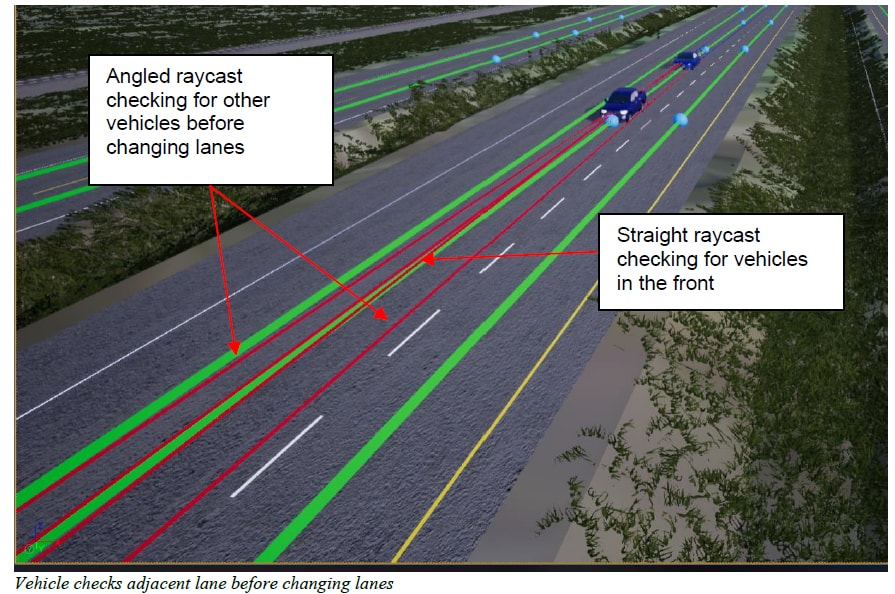
- Realistic lane changing to avoid slowing or stopping in traffic (Sensor and data based)
- Variable speed based on vehicle type and speed limit
- Supplemental data/signage displays in 3D (Floating signs always facing camera)
- Automobiles are built with intelligent lane change capabilities.
- Pedestrians and bicycles are core entities with special built in behaviors that can be integrated into any traffic simulation network.
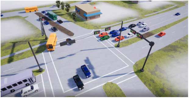
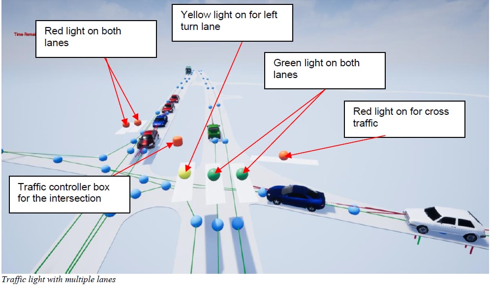
Traffic Control Devices in AtSim
AtSim can simulate the following traffic devices with real world control patterns: Traffic lights for any number of lanes, including turn lanes that supports multiple patterns, and stop signs for all way stops or partially controlled intersections.
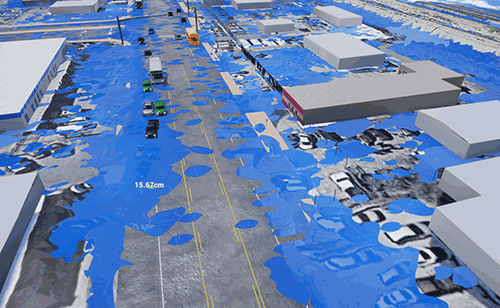
Floodwater Mapping (AtSim Hydro) 
AtSim has the capability to incorporate accurate floodwater mapping based on raster images of historical data. AtSim Hydro features include Flood Water pooling and traffic effect integration. Traffic integration includes slowing down, changing lanes, and stopping for areas of deep water. AtSim Hydro uses modifiable settings to control flood water traffic interactions, by default AtSim Hydro uses the current TxDOT safety recommendations.
Ready To Start Your AtSim Service?
Location:
1322 Space Park Dr, Suite C134,
Houston, TX 77058
Email:
info@atlinkcom.com
Call:
United States : (281) 645-6907
Sri Lanka : +94 0112675602